Google Earth is getting better and better and will soon be almost as good as actually being there. Don’t beleive me? I decided to pick a couple of shots and line up the same view in Google earth to compare. This first photo is from San Bruno Mountain (original photo here), showing the San Francisco skyline:
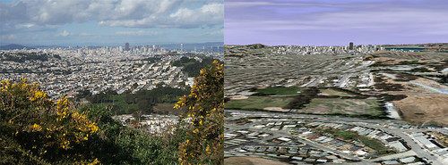
You should definitely click through to see the full-sized version. The version on the right is missing the flowers in the foreground and the clouds are a little different but otherwise it’s very recognizable.
Here’s another shot of San Francisco, this one from the bay (original photo here). I thought this would show off the detail of some of the 3d buildings in Google Earth. I had a hard time lining up a large screenshot because the photo was taken at 8x zoom, but you get the idea.
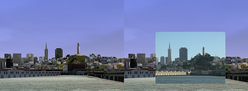
Again, you should click though to the full sized version to get the full effect.
What do you think? Will Google Earth evolve to the point where no one will ever need to travel? My guess is that people will still get wanderlust and until Google unveils a food modem you’ll have to go get the sourdough yourself.
Let me know if you liked these in the comments and I’ll do a few more.
Cool idea, I’m about to go rig up some comparisons of Boston now.
Isn’t travelling about new people, new places, new experiences?
I hope Google ain’t adding that to Google Earth any time soon; RL has to be worth something!
Hi,
I think it would be great to see the pictures right in Google Earth. Would it be possible to publish the kmz-files?
Great work.
Actually, Maarten, that’s my next plan. Wysz pointed out a tool to make it easy to do, too. Just have to find a couple of spare minutes.